By Erin Driscoll
For thousands of years before Europeans arrived, Native Americans lived on the narrow 800-acre Shawmut Peninsula. As illustrated in “Boston Over Time: Filling In the Land 1630-Present,” much of modern Boston rests on nearly 5,000 acres of added land, the result of hundreds of years of landmaking projects. Boston’s long history of land creation can sometimes place the city we know aboveground at odds with the story told below street level. The maps and artifacts featured in “Beneath Our Feet: Mapping the World Below” help us to navigate Boston’s changing landscape and glimpse its pre-colonial human history.
 It is hard to imagine fishing from the middle of Boylston Street today, but thousands of years before Bostonians filled in Back Bay, the area was a tidal mudflat, ideal for catching fish. Native Americans took advantage of the tides and constructed fish weirs, fence-like structures made out of sticks and rocks that would channel fish over during high tide and trap them as the tides receded. A lawyer with a passion for archaeology spotted these fish weir stakes in 1913 as he walked by a construction site for Boston’s first streetcar system. He understood the significance of these twisted, carved wooden stakes and took them home to place them in in the mason jar full of water that houses them today. It may seem counterintuitive, but the groundwater beneath Boston’s added land is essential to preventing the growth of microorganisms that rot wood. There are an estimated 60,000 of these stakes in the marine clay beneath today’s Back Bay, with a period of use dating back between 3,600 and 5,200 years.


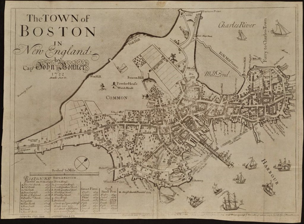
The oldest man-made artifact found beneath Boston is the Neville Point, a 7500-year-old stone point for a spear or a knife. The Point predates the use of bow and arrows in the area and would have been used for hunting. It was found beneath the site of the Great Elm in Boston Common, a tree so large and distinctive that it earned its place as a landmark on many early maps of Boston, including John Bonner’s famous map “The Town of Boston in New England” (1723). Bonner’s map gives us a sense of the shape of colonial Boston before major land-making projects had begun. Boston Common is archaeologically valuable because it is one of the least developed areas in Boston and it is a part of the original landmass.
At the turn of the 17th Century, Native Americans living in the Shawmut Peninsula were trading with Europeans for goods such as copper kettles. They would melt down these kettles to rework the raw materials into jewelry and tools such as this copper arrowhead, discovered in Boston Common in 1986. In his book A History of Boston in 50 Artifacts, Boston’s City Archaeologist Joe Bagley describes this copper arrowhead as being representative of an “overlap of cultures and a transition between two peoples that would forever change the historical narrative of the place that became Boston.” Europeans would settle in the area in the second quarter of the 17th Century and begin the work of reshaping the Shawmut Peninsula into the city we know today.
To see these artifacts and delve deeper into Boston’s history below street level, visit “Beneath Our Feet: Mapping the World Below” at the Norman B. Leventhal Map Center at the Boston Public Library.
Erin Driscoll is a Gallery Attendant intern at the Norman B. Leventhal Map Center where she helps visitors engage with the map collection and exhibitions. A newcomer to cartography, she contributes to the Map Center’s social media accounts with the aim of demystifying map terms and concepts. She is pursuing a Master of Library Science degree through the University of North Texas.
Bibliography
Stephanie Cyr, curator. (2017). Beneath Our Feet: Mapping the World Below.
Bagley, Joseph M. A History of Boston in 50 Artifacts. University Press of New England, 2016.
Seasholes, Nancy S. Gaining Ground: A History of Landmaking in Boston. Cambridge, Mass.: MIT Press, 2003. [F73.3 .S46 2003]
Chan Krieger & Associates. “Boston Over Time.” 2008. Norman B. Leventhal Map Center, https://collections.leventhalmap.org/search/commonwealth:q524n559t (accessed October 22, 2017).
Banner Image
Bonner, John, Price, William. “The town of Boston in New England.” 1723. Norman B. Leventhal Map Center, https://collections.leventhalmap.org/search/commonwealth:9s161f21f (accessed October 22, 2017).


